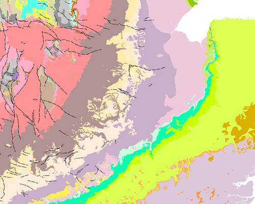
Generalised digital geological map data based on BGS's published poster maps of the UK (North and South).
Bedrock related themes created by generalisation of 1:50 000 data to make the 2007 fifth edition Bedrock Geology map.
Generalised digital geological map data based on BGS's published poster maps of the UK (North and South).
Bedrock related themes created by generalisation of 1:50 000 data to make the 2007 fifth edition Bedrock Geology map.
| Title | BGS Geology 625k (DiGMapGB -625) language=en |
|---|---|
| Label | Digital Geological Map Data of Great Britain - 625k (DiGMapGB-625) 2008 language=en |
| Description | Generalised digital geological map data based on BGS’s published poster maps of the UK (North and South). Bedrock related themes created by generalisation of 1:50 000 data to make the 2007 fifth edition Bedrock geology map. NB Superficial units that are part of BGS Geology 625K (DiGMapGB -625) are not included in this distribution. language=en |
| Is Format Of | http://data.bgs.ac.uk/id/dataHolding/13480426. language=en |
| About | BGS Geology 625K (DiGMapGB -625) datatype=xsd:anyURI |
| Has part |
Bedrock Units Faults Dykes Superficial Units [not yet available in linked data format] |
| See also |
BGS Geology 625k | DiGMapGB-625 Web Map Services (WMS) iGeology App |
| Created | 2008-01-01 datatype=xsd:date |
| Publisher | British Geological Survey |
| Creator | British Geological Survey |
| Type | skos:ConceptScheme |
| Identifier | "http://data.bgs.ac.uk/ref/625KGeologyMap" language=en |
| HTML | RDF/XML | Turtle | N-Triples | JSON | |
 Contains sub-schemes